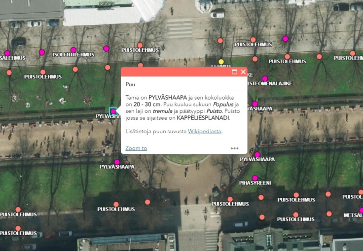
Skip to content
  • FI
  • EN
  • SV
Helsinki • Espoo Site logo Vantaa • Kauniainen
Helsinki • Espoo • Vantaa • Kauniainen
  1. Home
  2. Showcases
  3. Helsingin puut

Helsingin puut

Visualisations
  • trees
  • nature
  • vegetation
  • timber
Antti Ahola - Published 21.5.2019 - updated 18.12.2019
  1. 2019-05-21-094527.275071puu1.jpg
  2. 2019-05-21-094527.367207puu2.jpg

Visualisointi, jolla voi tarkastella Helsingin kaupungin puurekisterin tietoja ilmakuvan päällä.

Lisätietoa ja ohjeet visualisoinnin tekemiseen: https://paikkatietoopas.com/2019/05/21/karttasovelluksen-avulla-tiedat-mita-puuta-juuri-halasit/

Used datasets

  • Orthophotographs of Helsinki

    This dataset provides the orthophotographs of Helsinki in GIS API from 1932 to present day. Additionally, photos from 1988, 1976, 1969, 1964, 1950, 1943 and 1932 are provided as...
    • WMS
    • WMTS
    • TIFF
  • Urban tree database of the City of Helsinki

    The Urban tree database of Helsinki (Puuatlas) is a system of the City of Helsinki’s Urban Environment Division that contains information about the street and park tree assets...
    • WMS
    • WFS

More from the author

  • Katutyöt Helsingissä

  • Kartta paljastaa alueet, joilla bussi kulkee harvoin

  • Mistä kadunnimet ovat peräisin?

  • Kaunis Helsinki

  • Onko pääkaupunkiseutu jo täyteen rakennettu?

Show all from this author
Application website arrow_forward Author website arrow_forward

More from the author

  • Katutyöt Helsingissä

  • Kartta paljastaa alueet, joilla bussi kulkee harvoin

  • Mistä kadunnimet ovat peräisin?

  • Kaunis Helsinki

  • Onko pääkaupunkiseutu jo täyteen rakennettu?

Show all from this author
  • Data portal arrow_forward
  • Content management arrow_forward
Site logo
Follow us